-
 10
11
12
13
14
15
16
17
18
19
20
10
11
12
13
14
15
16
17
18
19
20

紀要『アート・リサーチ』24-2号の原稿募集を開始しました
本紀要は、アート・リサーチセンターで展開する各研究プロジェクトの活動成果を広く公開する目的を持つとともに、芸術文化を専門とした学術雑誌として、例年多くの方にご投稿いただいております。
アート・リサーチセンターは、1998年度設立以来、文化・芸術・情報科学に関する優れた研究拠点として、国の複数の補助金に採択され、2019年度には文部科学省「国際共同利用・共同研究拠点」として認定されるなど、研究を一層深化させています。また、文化芸術のデジタルアーカイブにおける先端的拠点としても、高く評価されています。オンラインジャーナルとして年複数回発行し、年度末には、それらをまとめた冊子も発行します。
続きを読む>>
原稿募集は随時行っております。
投稿機会の自由度が大幅に高まりますので、是非とも積極的なご応募をお待ちしております。Background:
Supported by the ARC-iJAC, the research led by Dr. Ewa Machotka and Dr. John Pavlopoulos (Stockholm University) has pursued the large-scale digital geospatial exploration of places depicted in Japanese early modern ukiyo-e landscape prints through Natural Language Processing (FY 2021). Their follow-up project aims to apply NLP technology to inscriptions on ukiyo-e landscape prints to facilitate a large-scale exploration of textual information featured in those prints (FY 2023).
Project leader: Dr. Ewa Machotka (Dept. of Asian and Middle Eastern Studies, Stockholm University)
Project manager: Dr. John Pavlopoulos (Dept. of Computer and Systems Sciences, Stockholm University)
Project members: Konstantina Liagkou, Panagiotis Papapetrou, Marita ChatzipanagiotouThank you very much for your time today. Could you please tell us the motivation for your ARC-iJAC research project Natural Language Processing for a Geospatial Exploration of Japanese Ukiyo-e Prints?
 Machotka: The last several decades saw the rise of interest in the concept of Global Art History, understood as a heterogenous transnational and critical study of the world's cultural production. One of the challenges of this new research direction is the question of how to acknowledge the conceptual and material heterogeneity of artistic production across the world in a way that does not support a universalist understanding of cultures. This concern prompted our research. We saw that Japanese early modern landscape prints, as globally recognizable non-Western pre-modern artifacts, offer a critical testbed for considering these issues.
2023年4月12日(水)18:00より、Web配信にて第115回国際ARCセミナーを開催いたします。
プログラムは下記となります。講師:上野隆三氏(立命館大学学⻑特別補佐、文学部教授)
タイトル:「浮世絵から見る“三国志”の日本における受容」
日時:2023年4月12日(水)18:00~19:30
参加:Zoom配信(関係者のみ・予約不要)
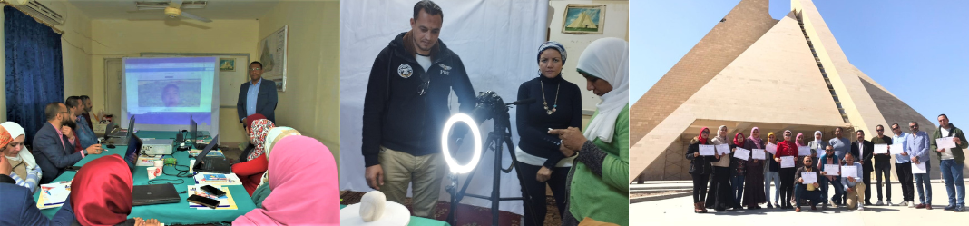
※YouTube配信はございません。[イベント情報]2023年3月13日(月)2023年3月7日-9日の3日間、エジプトのアトゥン博物館にてトレーニングコース「Generating 3D Model for Museums Collections Using Photo-Scanning Technique」が非公開で開催されました。
Overview:
Sharing knowledge and capacity building of curators working in the Egyptian museums at the Ministry of Antiquities is one of the important ways that achieve the required development of the policies and means of preserving the Egyptian cultural heritage in a sustainable framework. In this regard, sharing advanced practical know-how and experiences that have been developed with the Art Research Center (ARC) at Ritsumeikan University in Japan achieves this goal with the support of the Japan Society for the Promotion of Science (JSPS).
Objectives:
The photo-scanning technology contributes to preserving the objects of Egyptian museums, especially at the time of crises and disasters, such as the looting and destroying the Mallawi Museum in Egypt in August 2013, in addition to the massive destruction of the Islamic Art Museum after the Cairo Security Directorate bombing on January 24, 2014, the restoration and preservation of museum groups, add to contributing to the combating and recovery of smuggling of cultural heritage assets crimes.
The photo-scanning technique generates 3D modeling for artifacts in Egyptian museums. A digital database can be created and referred to, allowing the artifacts to be identified easily through fabric, components, and elements.
The dependence on the photo-scanning application on cultural heritage assets in Egyptian museums comes as a reflection of its practical and successful implementation on the objects of the Kyoto City Archaeological Museum in Japan under the supervision and support of the ARC. It aims to create 3D modeling of collected objects in a modernist geometric form (X, Y, Z) through precise photography with a special technique, processed with the Agisoft Metashape software v2021.
日時:2023年3月7日(火)-9日(木) 9:00-14:00 (EET)
会場:The Atun Museum, Minya Governorate, Egypt
主催:The Museums Sector at the Ministry of Tourism and Antiquities, Egypt
後援:立命館大学アート・リサーチセンター 国際共同利用・共同研究拠点「日本文化資源デジタル・アーカイブ国際共同研究拠点」(ARC-iJAC)[イベント情報]2023年3月 7日(火)2023年3月7日から9日にかけて、エジプトのThe Atun Museum, Minya Governorateでトレーニングコース「Generating 3D Model for Museums Collections Using Photo-Scanning Technique」が開催されます。
非公開イベントですのでご注意ください。
日時:2023年3月7日(火)-9日(木) 9:00-14:00 (EET)
会場:The Atun Museum, Minya Governorate, Egypt
主催:The Museums Sector at the Ministry of Tourism and Antiquities, Egypt
後援:立命館大学アート・リサーチセンター 国際共同利用・共同研究拠点「日本文化資源デジタル・アーカイブ国際共同研究拠点」(ARC-iJAC)Overview:
Sharing knowledge and capacity building of curators working in the Egyptian museums at the Ministry of Antiquities is one of the important ways that achieve the required development of the policies and means of preserving the Egyptian cultural heritage in a sustainable framework. In this regard, sharing advanced practical know-how and experiences that have been developed with the Art Research Center (ARC) at Ritsumeikan University in Japan achieves this goal with the support of the Japan Society for the Promotion of Science (JSPS).Objectives:
The photo-scanning technology contributes to preserving the objects of Egyptian museums, especially at the time of crises and disasters, such as the looting and destroying the Mallawi Museum in Egypt in August 2013, in addition to the massive destruction of the Islamic Art Museum after the Cairo Security Directorate bombing on January 24, 2014, the restoration and preservation of museum groups, add to contributing to the combating and recovery of smuggling of cultural heritage assets crimes.The photo-scanning technique generates 3D modeling for artifacts in Egyptian museums. A digital database can be created and referred to, allowing the artifacts to be identified easily through fabric, components, and elements. The dependence on the photo-scanning application on cultural heritage assets in Egyptian museums comes as a reflection of its practical and successful implementation on the objects of the Kyoto City Archaeological Museum in Japan under the supervision and support of the ARC. It aims to create 3D modeling of collected objects in a modernist geometric form (X, Y, Z) through precise photography with a special technique, processed with the Agisoft Metashape software v2021.
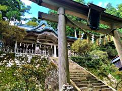
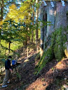
田中覚フェローらの世界遺産・玉置神社での研究プロジェクトが 正式にスタートしました。
関連記事
・RARA 研究活動レポート
・玉置神社
・<研究者インタビュー> 田中覚教授 (立命館大学情報理工学部 情報理工学科) “Visualizing Large-Scale Cultural Heritage”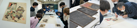
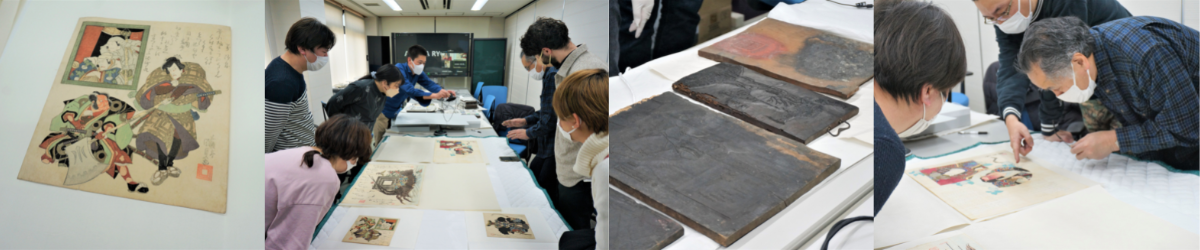
2023年2月17日、浮世絵木版画彫摺技術保存協会とのワークショップが、アート・リサーチセンター 文部科学省 国際共同利用・共同研究拠点「日本文化資源デジタル・アーカイブ国際共同研究拠点」(ARC-iJAC)との共催のもと、開催されました。
ARCと浮世絵木版画彫摺技術保存協会との間には長年の協力関係があり、これまでに2011年2月、2015年2月、2019年6月、2022年2月にワークショップが開催されてきました。
ワークショップを通して、彫摺技術に関する情報交換・意見交換を行い、ARC所蔵資料に対する理解の深化、拠点メンバーの彫摺技術に対する知見の深化を図ることを目的としています。
浮世絵木版画彫摺技術保存協会について、
文化財保護法第147条に基づき、昭和53年に浮世絵木版画の彫師・摺師の技術が選定保存技術に選定され、浮世絵木版画彫摺技術保存協会が選定技術保持団体として認定されています。>>浮世絵木版画彫摺技術保存協会
日時:2023年2月17日(金)14:00~17:00
開催方法:オンライン開催(Zoom)
登壇者(話題提供者)・テーマ:
赤間亮(立命館大学アート・リサーチセンター センター長)
「海外の浮世絵コレクション紹介 欧州ドイツ編」
金子貴昭(立命館大学衣笠総合研究機構 准教授)
「立命館大学アート・リサーチセンターの板木コレクション」
松葉涼子(セインズベリー日本藝術研究所 Lecturer)
「Connecting Present to Past: Re-evaluating Japanese Traditional Printmakingプロジェクト報告および葛飾北斎作品の彫、摺の疑問点」
2023年2月18日(土)、知識・芸術・文化情報学研究会主催の第12回 「知識・芸術・文化情報学研究会」が、アート・ドキュメンテーション学会関西地区部会・情報知識学会関西部会共催、立命館大学アート・リサーチセンター 文部科学省 国際共同利用・共同研究拠点「日本文化資源デジタル・アーカイブ国際共同研究拠点」協力のもと開催されました。
またこの会は、ARC-iJACの若手研究者カンファレンスとして位置付けられています。
新型コロナウィルス感染症拡大防止のため、今回はZoomでの無料開催となりました。
「知識・芸術・文化情報学研究会」詳細:
昨今のデジタル・情報環境の急速な進展とともに、学術分野にも「情報」や「デジタル」を意識した分野横断型の研究が多く見受けられるようになってきました。大学の教育・研究活動においても、この傾向は強まっており、これに関連する教育プログラムやコースの活動が充実しています。
時代に即した新しい研究テーマのもと、このような課程で学ぶ学部生・大学院生や若手研究者が学術的な交流をする機会へのニーズはますます大きくなっています。
そのため、芸術・文化、およびその他の関連する分野の情報・知識研究に興味のある大学院生および若手研究者を主に意識し、発表・交流のための場として「知識・芸術・文化情報学研究会」を2011年度に発足させ、これまで11回の研究集会を開催しました。
本会は、異分野の人的交流を通じて、参加者相互が新たな研究テーマや方法を発見できる場と位置づけており、学会発表とはひと味違う萌芽的・冒険的な発表も歓迎します。■ 日時:2023年2月18日(土)13:00開始
■ 実施方法:オンライン開催(Zoom使用)
・発表募集ではハイブリッド開催としておりましたが、新型コロナウイルス感染状況を考慮し、完全オンラインで開催することとなりました。
・ アクセス方法は発表者および参加申し込みをいただいた方にメールでお知らせします。
・ 会場による開催はございませんのでご注意ください。主催:知識・芸術・文化情報学研究会
世話役〔五十音順〕:赤間亮(立命館大学)、阪田真己子(同志社大学)、田窪直規(近畿大学)、村川猛彦(和歌山大学)
共催:情報知識学会関西部会、アート・ドキュメンテーション学会関西地区部会
協力:立命館大学アート・リサーチセンター
文部科学省 国際共同利用・共同研究拠点「日本文化資源デジタル・アーカイブ国際共同研究拠点」■ 参加申し込み方法
【募集は終了しました】※ 参加費は無料です。
続きを読む>>
※研究発表会後に懇親会(オンライン開催、無料)を予定しています。大学や分野の枠を超えた交流の場にしたいと思いますので、あわせてご参加ください。2023年2月18日(土)に、第12回 知識・芸術・文化情報学研究会を開催します。
下記の通り第12回の研究集会の参加者申し込みを受け付けておりますので、奮ってご参加ください。
またこの会は、ARC-iJACの若手研究者カンファレンスとして位置付けられています。「知識・芸術・文化情報学研究会」詳細:
昨今のデジタル・情報環境の急速な進展とともに、学術分野にも「情報」や「デジタル」を意識した分野横断型の研究が多く見受けられるようになってきました。大学の教育・研究活動においても、この傾向は強まっており、これに関連する教育プログラムやコースの活動が充実しています。
時代に即した新しい研究テーマのもと、このような課程で学ぶ学部生・大学院生や若手研究者が学術的な交流をする機会へのニーズはますます大きくなっています。
そのため、芸術・文化、およびその他の関連する分野の情報・知識研究に興味のある大学院生および若手研究者を主に意識し、発表・交流のための場として「知識・芸術・文化情報学研究会」を2011年度に発足させ、これまで11回の研究集会を開催しました。
本会は、異分野の人的交流を通じて、参加者相互が新たな研究テーマや方法を発見できる場と位置づけており、学会発表とはひと味違う萌芽的・冒険的な発表も歓迎します。■ 日時:2023年2月18日(土)13:00開始
■ 実施方法:オンライン開催(Zoom使用)
・発表募集ではハイブリッド開催としておりましたが、新型コロナウイルス感染状況を考慮し、完全オンラインで開催することとなりました。
・ アクセス方法は発表者および参加申し込みをいただいた方にメールでお知らせします。
・ 会場による開催はございませんのでご注意ください。主催:知識・芸術・文化情報学研究会
世話役〔五十音順〕:赤間亮(立命館大学)、阪田真己子(同志社大学)、田窪直規(近畿大学)、村川猛彦(和歌山大学)
共催:情報知識学会関西部会、アート・ドキュメンテーション学会関西地区部会
協力:立命館大学アート・リサーチセンター
文部科学省 国際共同利用・共同研究拠点「日本文化資源デジタル・アーカイブ国際共同研究拠点」■ 参加申し込み方法
続きを読む>>
2023年2月15日(水)までに、 参加申し込みフォーム よりお申し込みください。
※ 参加費は無料です。
※研究発表会後に懇親会(オンライン開催、無料)を予定しています。大学や分野の枠を超えた交流の場にしたいと思いますので、あわせてご参加ください。
10
11
12
13
14
15
16
17
18
19
20