-
An Interview with Dr. Hiroyuki Yamauchi (Associate Professor, Kinugasa Research Organization, Ritsumeikan University/ARC Research Manager)August 21, 2025(Thu)
Background:
Hiroyuki Yamauchi is an Associate Professor at the Kinugasa Research Organization, Ritsumeikan University, and a faculty member of the Art Research Center (ARC). He earned his master's degree in Letters from Nara University and went on to complete a PhD in Environmental Studies at the University of Tokyo.
His research focuses on the integration of Geographic Information Systems (GIS) with emerging technologies such as Virtual Reality (VR) and the metaverse to enhance geography education. By developing and evaluating educational materials through innovative technological approaches, he aims to make geography more accessible and engaging for learners. Dr. Yamauchi, thank you very much for your time today. To begin, could you share what initially sparked your interest in geography?
Yamauchi: Geography is a discipline that explores a wide range of phenomena occurring in physical space, from the natural environment to human life. Geography is fascinating in that almost anything can be connected into it. What first attracted my interest was the relationships between regional history and the natural environment.
Your research focuses on the use of innovative IT tools--such as Geographic Information Systems (GIS) and Virtual Reality (VR)--to develop and evaluate educational materials for geography classes. What inspired you to explore this intersection of technology and geography education?
Yamauchi: Over the past 30 years, Geographic Information Systems (GIS) have become widely adopted, leading to more diverse research methods in geography and applications of digital maps in society. Geographic information has become a fundamental technology for modern life, and its importance continues to grow. In fact, GIS is now part of the high school geography curriculum in Japan.
However, some high school geography teachers are still unsure how to use GIS and other digital tools effectively in the classroom. Technologies like GIS and Virtual Reality (VR) make it possible to simulate on-site exploration of local areas studied in the classroom.
Geography education has its roots in the academic discipline of geography, which values both a broad, map-based perspective and on-the-ground observation. Yet, in actual geography classrooms, students are sometimes simply taught to memorize technical terms. Some students also struggle with fundamental skills like reading maps and interpreting graphs.
For this reason, modern geography education should offer more immersive, intuitive learning experiences and teaching materials that lower the barriers to understanding. To achieve that, it is essential to leverage digital technology.
Could you share some specific examples from your research that illustrate how these technologies are being used to enrich geography education in the classroom?
Yamauchi: One example of using GIS in the classroom is a lesson that incorporates three-dimensional digital maps. For instance, when explaining alluvial fans, it can be difficult for students to grasp the slope of the terrain using a two-dimensional map, but this becomes much easier to understand when viewed in 3D.
GIS also allows users to switch between different types of maps, such as from topographic maps to aerial photographs, enabling students to observe patterns of land use more clearly. In this way, GIS provides a range of information that helps students gain an overview of regional characteristics. More advanced applications of GIS can also be used to analyze data such as population density, aging rates, and other information.
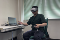 While GIS is excellent offering a bird's-eye view of a region, it presents information from a different perspective than what we typically see in daily life, which can make it difficult for students to grasp the actual scale of things. In such cases, immersive VR teaching materials experienced through head-mounted displays can be particularly effective. In my collaborative research with other scholars, we have conducted 3D measurements of various regional terrains and historical sites to develop VR-based educational materials.
One example is a project involving the Taya Cave (Taya-San-Yu-Ga-Dou) in Sakae Ward, Yokohama. This is a man-made cave used as a training site for Shingon Buddhism and its walls are adorned with a wide variety of Buddhist relief carvings. Based on the cave's 3D data, we developed a VR application that allows users to explore the cave's interior, offering them a highly immersive and satisfying experience.
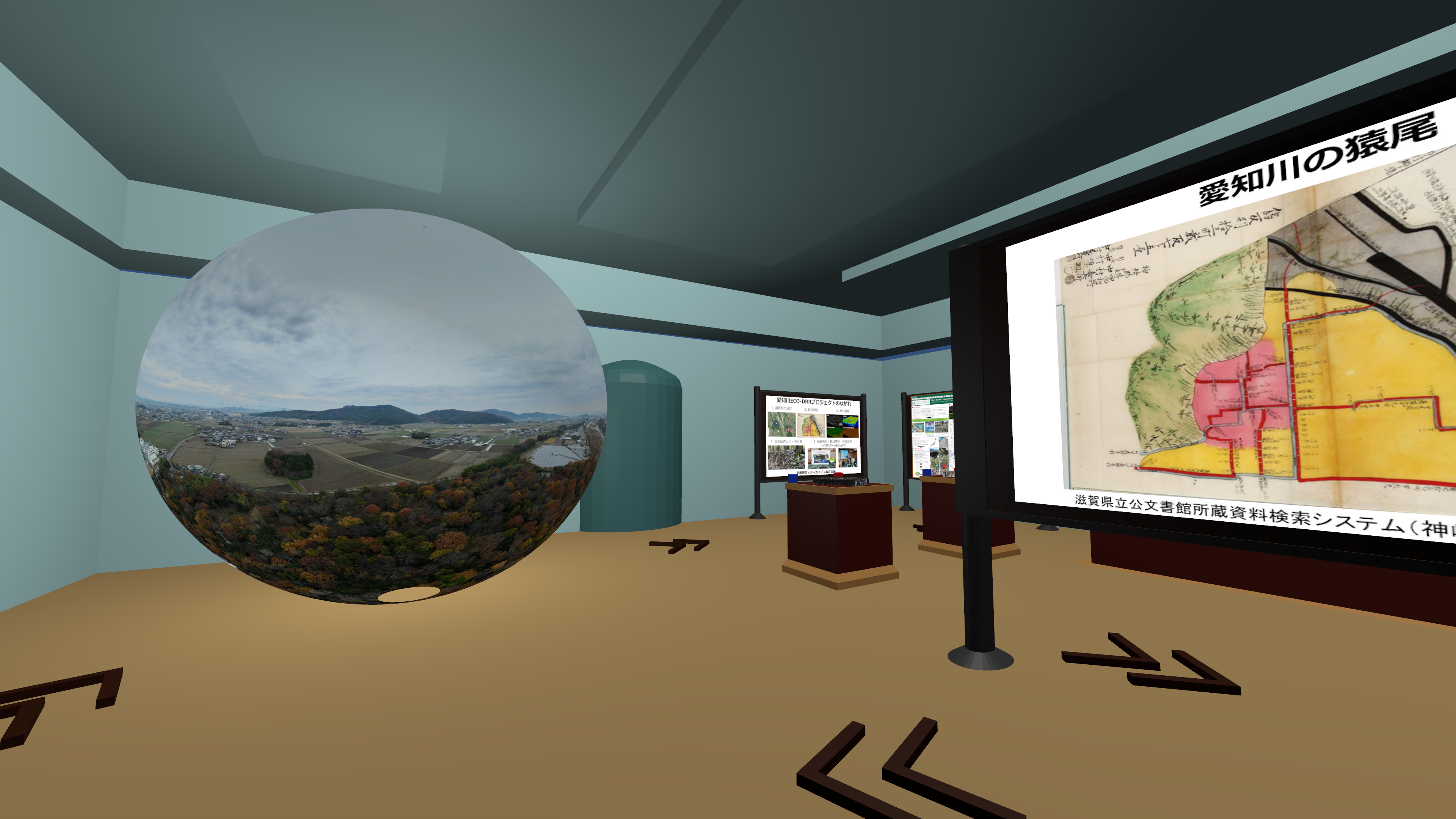
Another case involves a virtual museum that recreates Saruo structures found along the Echi River basin in Shiga Prefecture.
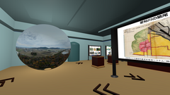
Saruo are traditional groynes built along riverbanks to redirect water flow during heavy rain and prevent flood damage. Over time, due to changes in the local residents' lifestyles, knowledge of these structures had faded from collective memory.
Our research team launched a project to rediscover existing Saruo remnants, preserve them through digital archiving, and raise awareness among local communities. As part of this effort, we created a virtual museum in a VR environment that exhibits information about Saruo. It is often difficult to get people interested in things they have never seen or places they have never been, but by using digital technologies, we can offer engaging and meaningful experiences.
In addition to your research, you lead the ARC's Technical Support Board. What are some of your main responsibilities in this role?
Yamauchi: At the Art Research Center (ARC), researchers from various fields in the humanities are engaged in joint research activities under the MEXT-accredited International Joint Digital Archiving Center for Japanese Art and Culture (ARC-iJAC). As my area of expertise is Geographic Information Science, I provide support to ARC-iJAC members by sharing knowledge related to digitized paper maps and geographic data.
Some cultural resources--such as paintings or photographs--depict actual landscapes. By managing these materials with geospatial data, they can be visualized as maps using GIS. I also offer guidance on handling three-dimensional data obtained through techniques such as photogrammetry.
How we archive spaces and spatially related cultural resources, and how we make use of them, is a matter of shared interest among many researchers. I believe this makes it an important area of contribution. On the other hand, using GIS comes with its own unique challenges. For researchers from other disciplines to use GIS effectively, they need both adequate technical support and opportunities to understand the value that GIS can offer.
Going forward, I believe it is essential to further strengthen these kinds of interdisciplinary support initiatives.
How does the Technical Support Board (TSB) contribute to the ARC's long-term vision, and what role do you see it playing in shaping the future direction of the Center?
Yamauchi: At the Art Research Center (ARC), we provide support for the use of GIS for ARC-iJAC researchers through the Technical Support Board. The ARC's Map Database features a wide range of Japan-related maps, including historical map collections from institutions like the British Library. We are also working on the provision of map data through the IIIF (International Image Interoperability Framework) platform.
Since the last fiscal year, we have begun offering access to accounts for the ArcGIS Online platform provided by Esri. This enables researchers affiliated with the Center to utilize applications commonly used by experts in geography at a low cost.
Looking ahead, how do you envision emerging IT technologies contributing to the future development of geography education?
Yamauchi: To advance geography education, I believe it is essential to introduce and consider IT technologies from two key perspectives: "educational materials" and "assessment systems."
In terms of the educational materials, it is important to apply various technologies to education in order to realize both "geography learning with satisfaction" and "clear, comprehensible teaching." While the use of GIS is one example, technologies such as AR, VR, the metaverse, and AI also have great potential to make geography education more engaging.
At the same time, we also need to think carefully about how learning is assessed. When both the teaching materials and the assessment systems are developed in tandem, and can provide feedback to each other, it becomes possible to achieve a more fulfilling educational experience.
For instance, if we create a metaverse-based digital space that reproduces the real-world locations found in geography textbooks, it would be possible to simulate something like a field trip within that space. In such an environment, teachers could give lessons as if they were on-site, explaining terrain and townscapes, while learners could explore the area freely as they study.
The ability to record data on how students learn and interact within that digital environment--combined with other sources of information--would allow educators to objectively evaluate the effectiveness of their teaching methods, and to offer more targeted advice on how students should observe and interpret specific geographic features.
In this way, by expanding the learning environment beyond the physical classroom into immersive digital educational spaces, we can expect to improve education based on the data collected from those experiences.
(This interview was conducted by Yinzi Emily Li)


