-
Explore Professor Keiji Yano's Interactive 'Surname Map' to Understand the Geographic Distribution of Surnames Across JapanOctober 13, 2021(Wed)
 The Art Research Center (ARC), Ritsumeikan University, is delighted to announce the release of the 'Surname Map'--a research project led by Professor Keiji Yano (College of Letters), Deputy Director of the ARC.
Project Background
Until the end of the Edo period, Japanese surnames had exclusively been granted to the emperor, nobility, and samurais. Following the Meiji Restoration and the enactment of the family registration law in the early Meiji period, farmers and other commoners also began to adopt surnames.
With more than 100,000 different surnames, Japan is not only characterized by great diversity in surnames but also regional variations in their distribution.
Based on big data of about 40 million surnames from Japanese telephone directories and large-scale residential maps, the Surname Map visualizes the contemporary spatial distribution of surnames across all prefectures in Japan.
This research began in 2005 when Professor Yano, then a visiting researcher at University College London (UCL), joined Professor Paul Longley's research project on surnames around the world at the Department of Geography, UCL.
Professor Longley had mapped surnames from the UK's 1881 Census of Individual Voters and the 1998 Electoral Roll to analyze the movement of surnames over more than a hundred years.

In the UK, a country with an ethnically diverse population, he measured ethnic residential segregation by inferring ethnic origins from surnames.
For the project of Professor Longley to create a world map of surnames, Professor Yano provided the Japanese surnames.
Features of the Surname Map
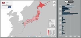
The interactive map provides users with valuable insights into the geographic distribution of their individual surnames in a simple and illustrative manner.
Firstly, the map displays the frequency of a surname in absolute numbers (人数) and ranking according to prefectures.
Secondly, the map shows the relative degree of accumulation, i.e., how evenly a surname is distributed throughout the country, with the specialization coefficient (特化係数).
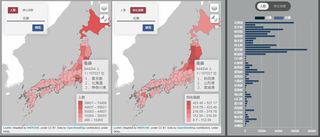
An option is available to display the absolute numbers and specialization coefficient on two maps side by side.
Furthermore, the distribution trends of two surnames can be compared side by side.
Explore Regional Variations
The map enables users to explore and identify the geographic concentration and regional clusters of surnames.
For instance, the map reveals that some surnames are particularly unique to a region, such as 'Ganaha' (我那覇) in Okinawa.
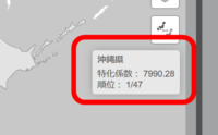
In the case of Okinawa, the heavy concentration of 'Ganaha' (我那覇) has been considered a result of the relative isolation of the Ryukyu Islands that has led to minimal surname exchange with mainland Japan, whereas there are different reasons for other localities, such as government policy implications on the settlement of Hokkaido.
Current & Future Research Endeavors
Professor Yano's Surname Map builds on the growing interest in the regional analysis of surnames in Japan and other parts of the world.
As in the UK, there exists no exhaustive historical surname data for the whole country in Japan. For Kyoto, however, a database has been created as part of the Virtual Kyoto Project--another project led by Professor Yano. He is working on establishing links within this data that comprise name data from land registry maps from the end of the Meiji period (1868-1912), telephone directories, and the names of people in commerce and industry during the Taisho period (1912-1926).
Other projects include an investigation in the hometowns of the Tonden soldiers (屯田兵) and migration flows of their descendants, identifying the hometowns of Nikkei (日系人) who emigrated from Japan, as well as a study of population movements in local areas of Japan over the past fifteen years, linking them to the census data at town and village levels.
Finally, Professor Yano is pursuing the possibility of digital humanities research on surnames, including the relationship between surnames and the name of places.
<Access the UK project 'Named by PublicProfiler' of University College London (UCL)>
The Surname Map has been created by Ritsumeikan University in cooperation with Acton Winds Co., Ltd.
Further reading:
1. Cheshire, James A., Paul A. Longley, Keiji Yano, and Tomoya Nakaya. "Japanese surname regions." Papers in Regional Science 93 (2014): 539-555. https://doi.org/10.1111/pirs.12002.
2. Longley, Paul. A., Alex D. Singleton, Keiji Yano, and Tomoya Nakaya. "Lost in Translation: Cross-Cultural Experiences in Teaching Geo-Genealogy." Journal of Geography in Higher Education 34, no. 1 (2010): 21-38. https://doi.org/10.1080/03098260902982476.
3. Yano, Keiji. "GIS based Japanese family name maps and their potential in Geographic Information Science." Jinmoncom (2007): 47-54. http://id.nii.ac.jp/1001/00100574/. (in Japanese with English abstract)