5| Notes to the catalogue
-
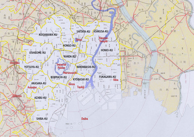
This exhibition guides you through Tokyo's neighborhoods as they were during the inter-war years, primarily after 1923, the date of the Great Kantō Earthquake. Taking today's wards, or ku, as a point of reference, we highlight, one by one, the wards as illustrated by the artists of the 1920s and 30s.
During the Tokugawa era (1603-1868), Tokyo, then called Edo, was roughly divided into two parts: the 'high city' containing the daimyō mansions, and the 'low city' inhabited by the Edo townspeople (chōnin). The high city was located on the hills to the west and the low city on the flat planes to the east. Edo underwent tremendous changes when the Emperor, as the head of state, arrived from Kyoto and settled here. The onset of the Meiji era (1868-1912) brought rapid modernization, and the name of the city was changed to Tokyo. The 1923 earthquake, followed by systematic allied bombing 20 years later, transformed Tokyo again.
But even in the Shōwa era (1926-1988), many neighborhoods retained visible elements of their history. Akasaka and Azabu, for example, remained posh, upscale neighborhoods. Areas like Ginza, Shinjuku, and Shibuya, on the other hand, were places of little or no importance during the Edo period, but have since shown spectacular developments in urban activity and specialization. We will start our journey at the very heart of the city, at the Imperial Palace, in present-day Chiyoda-ku, then called Kōjimachi-ku.
-
Related Entries
-
Kōjimachi-ku and Kanda-ku (present-day Chiyoda-ku)
Although Kōjimachi and Kand...
-