- 歴史地理情報研究班
- その他 [12]
- ミーティング [7]
- 研究動向 [7]
- セミナー・ワークショップ [10]
- デジタルミュージアム [2]
- 京町家まちづくり調査 [7]
- 学会・イベントの案内 [25]
- 学会報告の告知 [27]
2009年10月13日
22nd CIPA International Symposiumにおける発表
https://www.arc.ritsumei.ac.jp/lib/mt_gcoe/mt-tb.cgi/12702009年10月11日から15日の会期で、CIPA(文化遺産ドキュメンテーション国際委員会:The International Committee for Documentation of Cultural Heritage、http://cipa.icomos.org/)の国際シンポジウムが開催されることになりました。
当研究班メンバーが、本カンファレンスにて研究成果を講演・発表します。詳細は公式ページをご覧ください。研究発表は下記のセッションになります。
Tuesday, 13th October 14:30-16:00 Poster Session 1
Iizuka, T., Matsumoto, A., Seto, T., Yano, K.
GIS-based Monitoring Systems for Kyo-machiya in Kyoto City
Wednesday, 14th October 9:00-10:30 OS 13: VR Kyoto
Seto, T., Matsumoto, A., Iizuka, T., Yano, K.
Public Participation GIS of Historical Landscapes: A Case Study of "Kyo-machiya Community-building Survey" in Kyoto City
Kirimura, T., Yano, K., Kawaguchi, H.
Applicability of 3D GIS to the View Preservation Policy of Kyoto City
Hanaoka, K.
Spatial Microsimulation Modelling for Estimating Machiya Demolitions and the Preservation Policy Effects
Shibazaki, M., Isoda, Y., Tsukamoto, A., Kosaka, Y., Hasegawa, K., Nakata, S., Tanaka S.
Modeling, Viewing and Simulating Kyoto Street Models Created from GIS Data
22th CIPA International Symposium
DATE:11 -15 October 2009
Kyoto Terrsa, Japan
2009年9月11日
6th International Symposium on Digital Earth での発表
当研究班メンバーが、6th International Symposium on Digital Earth (ISDE6)にて、研究成果を発表します。詳細は公式ページをご覧ください。
研究発表は下記のセッションになります。
Thursday, 10th September, 15:30-17:30
"Virtual Environment for Digital Earth"
Keiji YANO, Tomoki NAKAYA, Satoshi TANAKA, Yuzuru ISODA, Toshikazu SETO, Yutaka TAKASE, Takafusa IIZUKA, Ayako MATSUMOTO, Takashi KIRIMURA and Akihiro TSUKAMOTO
Virtual Kyoto as Historical Virtual Geographic Environments: Restoring and Visualizing Changes of Urban Landscapes
6th International Symposium on Digital Earth
DATE:9 -12 September 2009
Beijing International Convention Center, China
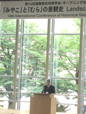
2009年8月23日
ICHG2009 Opening Session
International Conference of Historical Geographies 2009のオープニング・セッションが、京都大学百周年時計台記念館「百周年記念ホール」で開催されました。
冒頭に、本カンファレンス組織委員長の金田章裕教授から趣旨説明と、本研究班から矢野桂司教授・金田章裕教授がそれぞれ講演しました。
2009年8月23日
14th International Conference of Historical Geographersでの発表
当研究班メンバーが、14th International Conference of Historical Geographers(第14回国際歴史地理学会)にて、研究成果を講演・発表します。詳細は公式ページをご覧ください。
研究発表は下記のセッションになります。
Sunday, 23rd August 14:00-15:30 Opening Session: Landscape History of Japan
Keiji YANO
Virtual Kyoto: Historical Virtual Geographic Environments
Akihiro KINDA
National Institutes for the Humanities Characteristics of the Japanese Cultural Landscapes
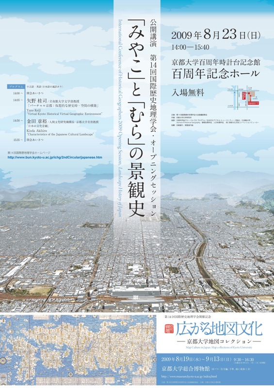
24日以降の発表予定は、続きページをご覧ください。
続きを読む>>
2009年7月25日
「Historical GISの地平」シンポジウムでの発表
当研究班メンバーが、人文地理学会歴史地理研究部会主催のシンポジウムにて、研究成果を発表します。詳細は公式ページをご覧ください。
当研究班メンバーの研究発表・コメントは下記のセッションになります。
13:15-15:45 セッション2(時空間分析システム)
コメンテーター:矢野桂司(立命館大学)・門林理恵子(情報通信研究機構)
16:00-18:00 セッション3(古地図の蓄積・分析)
研究発表:近世京都の刊行都市図に描かれた空間・・・塚本章宏
「Historical GISの地平」シンポジウム
DATE:2009年7月25日
帝塚山大学東生駒キャンパス7号館5104教室
2009年6月23日
digital humanities 09 での発表
当研究班メンバーが、digital humanities 09にて、研究成果を発表します。詳細は公式ページをご覧ください。
当研究班メンバーの研究発表は下記のセッションになります。(※日時は現地時刻)
Tuesday June 23rd 15:30-16:00 Session #2
Akihiro Tsukamoto: A Historical GIS Analysis of the Landscape Compositions: A Case Study of Folding Screens “Rakuchu-Rakugai-zu”
Thursday, June 25th 10:30-11:00 Session #5
Keiji Yano: From the Local to the Global Sphere: Prospects of Digital Humanities: Putting the Jigsaw Together
digital humanities 09
DATE:22 -25 June 2009
University of Meryland, USA
2009年6月13日
日本文化財探査学会第12回大会での発表
当研究班メンバーが、日本文化財探査学会第12回大会の特別講演会にて、研究成果を発表します。詳細は案内ページをご覧ください。
当研究班メンバーの研究発表は下記の通りです。
6月13 日(土) 特別講演 15:20~17:30
15:20-16:20 特別講演会①
河角龍典(立命館大学文学部京都学プログラム)
「地理情報システムによる古代宮都の三次元ビジュアラーゼーション」
16:30-17:30 特別講演会②
矢野桂司(立命館大学文学部地理学教室)
「ディジタル・ミュージアムとしてのバーチャル京都」
日本文化財探査学会第12回大会
2009年6月13日-14日
立命館大学敬学館
2009年4月 1日
17th annual GIS Research UK (GISRUK) conference での発表
当研究班メンバーらが、17th annual GIS Research UK (GISRUK) conferenceにて、研究成果を発表します。詳細は公式ページをご覧ください。
当研究班メンバーの研究発表は下記のセッションになります。(※日時は現地時刻)
Wednesday 1 April 16:30-17:50 Session 3A GIS for health data
Tomoki Nakaya and Keiji Yano: Visualising spatio-temporal crime clusters in a space-time cube
Thursday 2 April 11:10-12:50 Session 5B Tools for spatial data handling II
Kazumasa Hanaoka: The estimation of the socio-economic impacts of machiya (traditional wooden townhouse) demolitions: A dynamic spatial microsimulation approach
17th annual GIS Research UK (GISRUK) conference
DATE:1 -3 April 2009
University of Durham
2009年3月28日
日本地理学会2009年春季学術大会での発表
当研究班メンバーらが、日本地理学会2009年春季学術大会にて、研究成果を発表します。
詳細は公式ページをご覧ください。
当研究班メンバーの研究発表は下記のセッションになります。
3月28日(土)10:40-11:00
805 飯塚隆藤・勝村文子・矢野桂司(立命館大)・西天平・森川宏剛(京都市景観・まちづくりセンター):第Ⅲ期京町家まちづくり調査の実施とGISデータベースの構築
P1032 桐村喬:2005年の東京23区の社会地区分析-外国人の居住地に注目して
3月29日(日)11:00-11:20
425 塚本章宏ほか6名 :13世紀平安京における火災発生地域の復原-GISを用いた都市空間構造の分析
426 村中亮夫・中谷友樹:災害復興における歴史的景観の経済評価
日本地理学会2009年春季学術大会
日時:2009年3月28日(土)・29日(日)・30日(月)
会場:帝京大学
2009年3月24日
CAA2009での発表
当研究班メンバーが、37th annual international conference on Computer Applications and Quantitative Methods in Archaeology (CAA)にて、研究成果を発表します。詳細は公式ページをご覧ください。
当研究班メンバーの研究発表は下記のセッションになります。(※日時は現地時刻)
Tuesday March 24, 2009, 8:30 am – 3:00 pm
139 Why did it take so long? spatio-temporal modeling and GIS
Ayako MATSUMOTO KATSUMURA, Takafusa IIZUKA, Keiji YANO, Tomoki NAKAYA, Tatsunori KAWASUMI, Yuzuru ISODA, Yutaka TAKASE, Keigo MATSUOKA, Toshikazu SETO, Dai KAWAHARA, Akihiro TSUKAMOTO, Manabu INOUE and Takashi KIRIMURA: Reconstruction of Machiya Landscape: 4DGIS Comprising Spatial and Temporal Dimensions
37th annual international conference on Computer Applications and Quantitative Methods in Archaeology (CAA)
DATE: March 22-26, 2009
Williamsburg, Virginia, USA
- 最近のエントリー
- AAG 2012 Annual Meetingでの発表
- 占領期を考えるワークショップ
- 国際GISセミナー: GIS and Digital Humanities
- 【告知】国際GISセミナーの開催
- 京都市明細図のWeb公開(京都府立総合資料館)
- アーカイブ
- 2012年4月 [1]
- 2012年3月 [3]
- 2011年7月 [1]
- 2011年6月 [1]
- 2011年5月 [1]
- 2011年4月 [1]
- 2010年12月 [3]
- 2010年11月 [5]
- 2010年10月 [6]
- 2010年9月 [6]
- 2010年8月 [2]
- 2010年6月 [2]
- 2010年5月 [1]
- 2010年3月 [1]
- 2010年2月 [2]
- 2009年12月 [1]
- 2009年11月 [2]
- 2009年10月 [3]
- 2009年9月 [5]
- 2009年8月 [2]
- 2009年7月 [2]
- 2009年6月 [5]
- 2009年5月 [1]
- 2009年4月 [8]
- 2009年3月 [3]
- 2008年12月 [3]
- 2008年11月 [4]
- 2008年10月 [3]
- 2008年9月 [2]
- 2008年8月 [3]